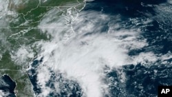
The U.S. National Hurricane Center reports a storm system moving up the U.S. East Coast is likely to strengthen in the next several hours and become Tropical Storm Ophelia as it moves on to land.
In its latest report, the hurricane center reports the storm was 405 kilometers east of Charleston South Carolina, and about 320 kilometers south of Cape Hatteras, North Carolina. It has maximum sustained winds of 85 kilometers per hour, putting it well beyond the minimum tropical storm wind speed of about 63 kilometers per hour.
Meteorologists with The Washington Post report the reason the storm has not yet been named, despite its strength, is because it formed as a wave of low pressure, without the closed surface with circulation and well-defined center associated with tropical storms and hurricanes.
But hurricane center forecasters report it is starting to change as the storm draws strength from the warm waters of the Gulf Stream in the western Atlantic. They said a hurricane hunter aircraft is expected to investigate the system later Friday.
The center reports that regardless of whether it is given a name, tropical storm conditions are expected, in the southeastern and Mid-Atlantic coastlines.
A storm surge warning is in effect from the community of Duck, North Carolina, to Chincoteague, Virginia, and the Chesapeake Bay, south of Windmill Point. The Neuse and Pamlico Rivers and portions of Pamlico and Albemarle Sounds also are under the storm surge warning.
There is the “danger of life-threatening inundation” with a storm surge warning, the center said, from rising water moving inland from the coastline.
Those residing in the area were urged to take “all necessary actions to protect life and property from rising water and the potential for other dangerous conditions.”
Meanwhile, a tropical storm warning is in effect from Cape Fear, North Carolina, to Fenwick Island, Delaware. Additionally, Albemarle and Pamlico Sounds, the Tidal Potomac River south of Cobb Island, and Chesapeake Bay south of North Beach are within the storm warning area, which could feel the effects of the system within 36 hours.


