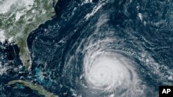
Hurricane Lee, which formed September 6 in the Atlantic Ocean before becoming a category 5 storm, continued north Thursday, triggering tropical storm warnings in Bermuda and threatening the northeast United States and Canada with a Saturday landfall.
In its latest report, the U.S National Hurricane Center said the storm was 425 kilometers southwest of Bermuda and about 1,280 kilometers south-southeast of Nantucket Island, Massachusetts on the U.S. east coast. It remains a Category 2 storm with maximum sustained winds of 155 km/h.
Tropical storm conditions were reported in Bermuda, with high winds, rough surge and two to five centimeters of rain expected across the island as Lee passed to the west.
Authorities closed schools and suspended ferry service while issuing high surf warnings.
Forecasters expect the storm to approach the New England region of the United States and the Maritime Provinces of eastern Canada in the coming days, where hurricane conditions are possible.
The Canadian Hurricane Centre said the storm will gradually weaken but expand in size, making landfall just below hurricane strength late Saturday or early Sunday.
Watches and warnings are in place for coastal areas of New England, stretching from Rhode Island to Maine, as well as Nova Scotia and New Brunswick in Canada.
In addition to rainfall amounts that could reach 10 centimeters, the Hurricane Center warned of a storm surge and life-threatening surf.
Ahead of the storm, parts of New England dealt with severe thunderstorms that brought flooding rains this week. The National Weather Service said the storms also spawned a likely tornado in Rhode Island and Connecticut.
Some information for this report came from The Associated Press.


