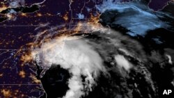
Tropical Storm Fay slightly picked up speed and strength as it moved closer to land Friday, and forecasters decreased projections for rain totals and flooding.
Fay was expected to bring 2 to 4 inches (5 to 10 centimeters) of rain, with the possibility of flash flooding in parts of the mid-Atlantic and southern New England, The U.S. National Hurricane Center said in its 5 a.m. advisory. That's down from earlier forecasts of about 3 to 5 inches (8 to 13 centimeters) of rain.
The storm picked up speed Friday morning, moving north around 10 mph (17 kph) and producing top sustained winds of 50 mph (85 kph), forecasters said. Earlier observations showed it moving at 8 mph (13 kph) with top sustained winds of 45 mph (75 kph).
A tropical storm warning remained in effect from Cape May, New Jersey, to Watch Hill, Rhode Island. The warning area includes Long Island and the Long Island Sound in New York, forecasters said.
Fay is the earliest sixth-named storm on record, according to Colorado State University hurricane researcher Phil Klotzbach. The previous record was Franklin on July 22, 2005, Klotzbach tweeted.
Two named storms formed before the official June 1 start of the hurricane season. None of this season's previous five named storms strengthened into hurricanes.


