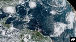
Hurricane Sally, one of five storms lined up as if on a conveyor belt across the Atlantic, churned toward the Louisiana-Mississippi coast Monday with rapidly strengthening winds of at least 145 kph (90 mph) and the potential for as much as 60 centimeters (23.5 inches) of rain that could bring severe flooding.
Storm-weary Gulf Coast residents rushed to buy bottled water and other supplies ahead of the storm, which was expected to reach Louisiana's southeastern tip around daybreak Tuesday and make its way sluggishly northward into Mississippi on a path that could menace the New Orleans metropolitan area and cause a long, slow drenching.
Forecasters said it could be a Category 2 hurricane with winds of 169 kph (105 mph) by the time it nears the coast. It would be Louisiana's second pounding from a hurricane in less than three weeks.
Jeremy Burke lifted things off the floor in case of flooding in his Bay Books bookstore in the Old Town neighborhood of Bay St. Louis, Mississippi, a popular weekend getaway from New Orleans, about 60 miles (95 kilometers) to the west. The streets outside were emptying fast.
"It's turning into a ghost town," he said. "Everybody's biggest fear is the storm surge, and the worst possible scenario being that it just stalls out. That would be a dicey situation for everybody."
Sally is perhaps the least welcome guest among lots of company: For only the second time on record, meteorologist Philip Klotzbach said, five tropical cyclones were churning simultaneously in the Atlantic basin.
In addition to Sally were Hurricane Paulette, which passed over a well-fortified Bermuda on Monday and was expected to peel harmlessly out into the North Atlantic, and Tropical Storms Rene, Teddy and Vicky, all of them out at sea.
As of midafternoon, Sally was about 260 kilometers (161 miles) southeast of Biloxi, Mississippi.
Sally's sluggish track could give it more time to drench the Mississippi Delta with rain and push storm surge ashore.
People in New Orleans watched the storm's track intently. A more easterly course could bring torrential rain and damaging winds to Mississippi. A more westerly track would pose another test for the low-lying city, where heavy rains have to be pumped out through a century-old drainage system.
Even with a push toward the east, New Orleans, which is on Lake Pontchartrain, will be in the storm surge area, said University of Miami hurricane researcher Brian McNoldy. He said New Orleans "should be very concerned in terms of track."
The National Hurricane Center forecast storm surges of up to 11 feet (3.4 meters), including 4 to 6 feet (1.2 to 1.8 meters) in Lake Pontchartrain and 6 feet in downtown Mobile, Alabama, a city of about 189,000 people.
In eastern New Orleans, drainage canals were lowered in anticipation of torrential rains, Mayor LaToya Cantrell said. New Orleans police went on 12-hour shifts, and rescue boats, barricades, backup generators and other equipment were readied, Police Superintendent Shaun Ferguson said.
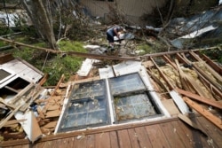
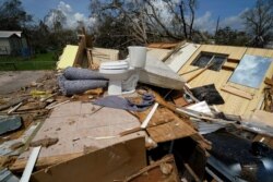
On Aug. 27, Hurricane Laura blew ashore in southwestern Louisiana along the Texas line, well west of New Orleans, tearing off roofs and leaving large parts of the city of Lake Charles uninhabitable. The storm was blamed for 32 deaths in the two states, the vast majority of them in Louisiana.
Other Gulf Coast states urged residents to prepare for Sally.
In Jackson, Mississippi Gov. Tate Reeves said the hurricane could dump up 51 centimeters (20 inches) of rain in the southern part of the state. Shelters opened, but officials urged people who are evacuating to stay with friends or relatives or in hotels, if possible, because of the coronavirus.
People in shelters will be required to wear masks and other protective equipment, authorities said.
"Planning for a Cat 1 or Cat 2 hurricane is always complicated," Reeves said. "Planning for it during 2020 and the life of COVID makes it even more challenging."
Alabama Gov. Kay Ivey closed beaches and called for evacuations.


