Hurricane Dorian will likely avoid landfall in Florida, but that does not mean residents of the Sunshine State or anywhere else along southeastern U.S. coast can relax.
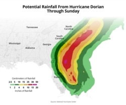
Forecasters say Dorian is getting bigger and will move "dangerously close" to Florida and Georgia Tuesday through Wednesday night, then threaten North and South Carolina with massive rainfall and powerful winds.
As of late Tuesday, Dorian was a Category 2 storm, about 200 kilometers east of Cape Canaveral, Florida, with top sustained winds of 175 kilometers per hour.
Tropical storm warnings are in effect for an area from near the Savannah River along the Georgia-South Carolina border north to Surf City, North Carolina.
Even if it stays offshore, Dorian's winds and rain extend 95 kilometers from the center and is expected to remain a powerhouse the rest of the week.
The National Hurricane Center in Miami cautions everyone along the Mid-Atlantic coast -- from Maryland to New York City -- to keep a close eye on Dorian.
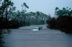
Dorian finally drifted away from the Bahamas Tuesday, leaving behind devastation described as "apocalyptic," "total," and looking as if a bomb had gone off.
The lack of wind currents in the atmosphere kept Dorian parked on top of Abaco and Grand Bahama Island for two days as a Category 4. It was the strongest storm ever to strike the Bahamas.
Initial reports say more than 13,000 homes were destroyed.
The runways at the Grand Bahama international airport are under water, making rescue efforts complicated.
Five deaths have been reported. But Lia Head-Rigby, who runs a hurricane relief organization on Abaco said bodies are being gathered.
She said it is no longer a question of rebuilding on Abaco; it is time to start over.


