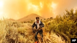
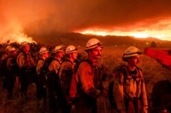
Firefighters struggled to contain an exploding Northern California wildfire under blazing temperatures as another heat wave hits the U.S. West this weekend, prompting an excessive heat warning for inland and desert areas.
On Friday, Death Valley National Park in California recorded a staggering high of 54 Celsius (130 degrees Fahrenheit). If verified, the temperature would be the highest recorded there since July 1913, when the same Furnace Creek desert area hit 57 C (134 F), considered the highest reliably measured temperature on Earth.
The Beckwourth Complex — two lightning-caused fires burning 72 kilometers (45 miles) north of Lake Tahoe — showed no sign of slowing its rush northeast from the Sierra Nevada forest region after doubling in size between Friday and Saturday.
Evacuation orders
California's northern mountain areas have seen several large fires that have destroyed more than a dozen homes. Although there are no confirmed reports of building damage, the fire prompted evacuation orders or warnings for about 2,800 people along with the closure of nearly 518 square kilometers (200 square miles) of Plumas National Forest.
On Friday, hot rising air formed a gigantic, smoky pyrocumulus cloud that reached thousands of feet high and created its own lightning, fire information officer Lisa Cox said.
Spot fires caused by embers leaped up to 1.6 kilometers (1 mile) ahead of the northeastern flank — too far for firefighters to safely battle, and winds funneled the fire up draws and canyons full of dry fuel, where "it can actually pick up speed," Cox said. The flames rose up to 31 meters (100 feet) in some places, forcing firefighters to focus instead on building dozer lines to protect homes.
Firefighters usually take advantage of cooler, more humid nights to advance on a fire, Cox said, but the heat and low humidity never let up. The more than 1,200 firefighters were aided by aircraft, but the blaze was expected to continue forging ahead.
The air was so dry that some of the water dropped by aircraft evaporated before reaching the ground, she added.
"We're expecting more of the same the day after and the day after and the day after," Cox said.
The blaze, which was only 8% contained, increased dramatically to 222 square kilometers (86 square miles) after fire officials made better observations.
It was one of several threatening homes across Western states, which were expected to see record heat through the weekend as high-pressure blankets the region.
The National Weather Service warned the dangerous conditions could cause heat-related illnesses, while California's power grid operator issued a statewide flex alert from 4 p.m. to 9 p.m. Saturday to avoid disruptions and rolling blackouts.
The California Independent System Operator (ISO) warned of potential power shortage, not only because of mounting heat but also because a wildfire in southern Oregon was threatening transmission lines that carry power to California. Governor Gavin Newsom issued an emergency proclamation on Friday suspending some rules to allow for more power capacity and ISO requested emergency assistance from other states.
Pushed by strong winds, the Oregon fire doubled in size to 311 square kilometers (120 square miles) on Saturday as it raced through heavy timber in the Fremont-Winema National Forest near the Klamath County town of Sprague River.
Conservation urged in Nevada
NV Energy, Nevada's largest power provider, also urged customers to conserve electricity Saturday and Sunday evenings because of the heat wave and wildfires affecting transmission lines throughout the region.
In Southern California, a brush fire sparked by a burning semitrailer truck in eastern San Diego County forced evacuations of two Native American reservations Saturday.
In Idaho, Governor Brad Little declared a wildfire emergency Friday and mobilized the state's National Guard to help fight fires sparked after lightning storms swept across the drought-stricken region.
Fire crews in north-central Idaho were facing extreme conditions and gusts as they fought two wildfires covering a combined 50.5 square kilometers (19.5 square miles). The blazes threatened homes and forced evacuations in the tiny, remote community of Dixie about 64 kilometers (40 miles) southeast of Grangeville.


