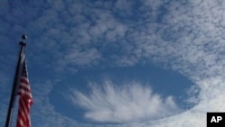
Scientists have found that aircraft flying through a layer of cold-temperature clouds can trigger a snowfall that normally wouldn’t occur.
The artificially-induced snow creates a great circular hole in the cloud layer. "Hole-punch" clouds are so rare and unique-looking, some witnesses have mistaken them for UFOs.
“Just do a search on hole-punch clouds on the web and you’ll see fabulous examples of what look like layer clouds with circular holes in them,” says Andy Heymsfield, senior scientist at the National Center for Atmospheric Research in Colorado and lead scientist on the study.
Three and a half years ago, he wasn’t attempting to link aircraft to hole-punch clouds. Instead, he and his colleagues were trying to understand how ice crystals form and develop in clouds.
Accidental discovery
“We had a research aircraft equipped with almost every imaginable probe for measuring the structure or the internal properties of these clouds,” he says.
One of these instruments was a cloud radar, a special device that can peer inside clouds just as an x-ray peers inside our body. About six months after their field work, a scientist studying the radar images stumbled across something very interesting, something he couldn’t explain.
"He passed through a very strange band of snow falling to the ground," says Heymsfield. "It was just fairly isolated. He noticed a very narrow line, but a long line, of precipitation that seemed to be coming out from a cloud deck up high."
There were no meteorological reasons why snow would be falling only along a linear path instead of over a wide area. So he turned to the other instruments to explain the phenomenon.
"On the aircraft we had digital photography looking forward and down so I could actually see what looked like snow reaching the ground and what looked like a line - a hole, canal or a channel in the cloud layer above," says Heymsfield.
Mysterious snowfall
The snowfall had hollowed out a long channel in the cloud. But there was still no explanation for what caused the line of snow, although Heymsfield had a hunch.
Reviewing the flightpaths of planes flying in and out of Denver International Airport, he found the snowfall followed the path a turboprop airplane had flown earlier that day.
“And in natural clouds you can have liquid water at temperatures in clouds down to as far as minus 40 degrees C before the droplets sort of automatically freeze,” he says.
In perfect conditions, aircraft can cool a cloud enough to generate those ice crystals.
The spinning propeller expands and cools the air behind it by as much as 30 degrees centigrade. Similar cooling occurs with jet aircraft. The pressure reduction over the wing which gives it lift also causes the air to expand and cool.
“Ice crystals upon which the ice can grow are introduced into a cloud, then the ice crystals will grow, the droplets will evaporate and you can generate snow.”
Airport connection
The next question was: can this happen around airports where there are a lot of commercial jet flights?
“We used satellite imagery to document that around airports with heavily trafficked areas conditions are just right fairly commonly- a winter month, maybe 10 or 15 percent of the time," he says. "When it does happen, ice crystals would be generated upwind of an airport, which could then drift over the airport and lead to more deicing operation”
Heymsfield says this phenomenon is not likely to affect global climate. Fellow cloud scientist, Patrick Chuang, agrees. But the associate professor of Earth and Planetary Sciences at the University of California, Santa Cruz, says the effect may skew climate records.
“I think the importance is in the fact that we really rely on airports to provide long-term records of weather, which then are used for things like climate change detection and just understanding how climate is changing," says Chuang. "It’s not like any cloud is conducive to this. I think it’s still not going to be a very commonplace event.”


