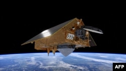
The U.S. space agency, NASA, in collaboration with the European Space Agency (ESA), is set to launch a satellite Saturday designed to monitor rising sea levels, the latest in a series of orbiting spacecraft monitoring the status of the world’s oceans.
NASA says the satellite, called the Sentinel-6 Michael Freilich, is scheduled to launch from Vandenberg Air Force Base in central California early Saturday. Named after former NASA Earth Science Division Director Michael Freilich, the U.S.-European satellite will be carried into space on a SpaceX Falcon 9 rocket.
The Sentinel-6 is about the size of a small pickup truck, and it will measure sea-surface height, wave-height and windspeed, allowing scientists to monitor changes in sea levels caused by climate change.
The data that it collects on sea level variations near coastlines will provide information to support coastal management and with planning for floods, while its atmospheric measurements will enhance weather and hurricane forecasts.
NASA Sentinel 6 mission scientist Craig Donlon says the data gathered by the craft will be used alongside information provided by previous Sentinel satellites to build a more complete a picture of the oceans.
"Sentinel-3 is providing the sea surface temperature and the ocean biology measurements. Sentinel-1 is providing radar imaging measurements of ocean swell waves, of sea ice. Sentinel-2 provides high resolution measurements in the coastal zone,” Donlon said.
Unlike previous Earth observation missions, the Sentinel-6 observatory will collect measurements at a much higher resolution and be able to measure smaller sea level variations near coastlines.
The satellite will be followed in 2025 by its twin, Sentinel-6B. Together, the pair is tasked with extending a nearly 30-year-long record of global sea surface height measurements.


