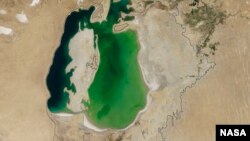
New NASA photographs taken by satellite show Central Asia' once-vibrant Aral Sea shrinking to levels possibly not seen in centuries.
The images taken in August by the Terra satellite show that the sea's eastern basin, on the border of Uzbekistan and Kazakhstan, completely empty, the first time in modern times, said Philip Micklin, a well-known geographer and professor emeritus of Western Michigan University and an Aral Sea expert.
"And it is likely the first time it has completely dried in 600 years, since medieval desiccation associated with diversion of the Amu Darya [river] to the Caspian Sea," he told NASA.
By some accounts, the destruction of the sea is considered one of the world's worst environmental catastrophes.
Once the fourth-largest sea in the world, the Aral has been shrinking since the 1960s when the Soviet Union undertook a major irrigation project to supply the arid plains of Kazakhstan, Uzbekistan and Turkmenistan.
The region's two main rivers — the Amu Darya and the Syr Darya — were tapped to irrigate water-intensive crops like cotton and others in the arid Central Asian desert.
The desert bloomed in many places, but at the expense of the lake, which has shriveled, destroying ecosystems, decimating a vibrant fishing industry and leaving dozens of communities suffering from poverty and environmentally-induced disease.
Micklin said lower rain and snow fall in the mountains to the east this year considerably reduced the flow into the Amu Darya feeding the lake.
Uzbekistan continues to use the river for its economically-important cotton industry.
As the water receded, the sea has split into two separate sections: the North, or Small, Aral Sea, located within Kazakhstan; and the South, or Large, Aral Sea. The latter split into western and eastern basins.
“As the lake dried up, fisheries and the communities that depended on them collapsed,” NASA noted in its statement that accompanied the publication of photographs. “The increasingly salty water became polluted with fertilizer and pesticides. Blowing dust from the exposed lakebed, contaminated with agricultural chemicals, became a public health hazard.”
The continual loss of water has also contributed to a change in the regional climate, making winters colder and summers hotter and drier, the statement said.
The photos of the drying lake were taken in August of this year by NASA's Moderate Resolution Imaging Spectroradiometer (MODIS) on the Terra satellite.
In an effort to save the lake, in 2005 a World Bank-funded dam was built in Kazakhstan, which has helped to partially restore the northern section, albeit at a fraction of its former size and volume.


