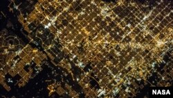
The National Aeronautics and Space Administration (NASA) has recently published a photograph of the Phoenix metropolitan area in the U.S. state of Arizona at night.
The “super view” -- as NASA has coined it -- shows parts of several cities in the metropolitan area, including Phoenix proper, Glendale, and Peoria.
A crew member of the Expedition 35 on the International Space Station used a camera with a 400 millimeter lens to take the photograph on March 16, 2013 from the low Earth orbit vantage point of the station.
Like many U.S. urban areas, the Phoenix metropolitan area -- often referred to as “The Valley of the Sun” -- is designed and built with a road infrastructure that forms a regular grid around blocks of commercial and residential buildings. Although quite visible during the day, this grid is especially noticeable at night from above, due to the pattern of street lighting.
It is the Grand Avenue that across the image center oriented northwest-southeast with brightly lit, easily visible, large industrial and commercial buildings along its length. Other brightly lit properties are shopping centers, rows of stores and service outlets.
The dark areas of the image are public parks and recreational land in the Phoenix Mountains at the upper right of the image, agricultural fields at the lower left, and the Salt River channel at lower right within the urban grid.


