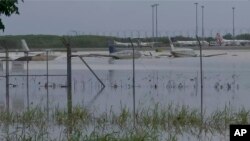
A tropical low strengthening over the Coral Sea on Tuesday is forecast to be the second cyclone in as many months to bring destructive winds and flooding to Australia's northeast coast.
The system, expected to be named Tropical Cyclone Kirrily later Tuesday or Wednesday morning, was tracking west toward the Queensland state coast near Townsville and forecast to make landfall overnight Thursday. Winds gusting up to 120 kph (75 mph) were expected as it crossed the Whitsunday Islands on Wednesday evening before increasing to 150 kph (93 mph) on the Australian mainland.
The same sparsely populated region was lashed in December by Tropical Cyclone Jasper, which had winds up to 140 kph (87 mph). It was the first tropical cyclone of the Australian season, which spans the hot southern hemisphere months of November to April.
Australian Bureau of Meteorology forecaster Laura Boekel said storm tides were expected to impact the coastal towns of Townsville and Mackay.
"The sea is expected to rise steadily up to a level well above the normal tide, with damaging waves and flooding of some low-lying areas, especially close to the shoreline," she said to the Australian Broadcasting Corporation.
Heavy to intense rain is forecast for other parts of Queensland when the storm heads inland, but authorities have stopped short of asking people to cancel their plans for the Australia Day holiday on Friday, but instead to be alert and monitor for warnings.
"We expect a lot of people on the roads this weekend because it is a long weekend, normally a time where we camp and enjoy the festivities," Queensland Police Commissioner Katarina Carroll said. "During the disaster season already, we lost seven lives ... within two days."
"We don't want to see that again — please stay connected."
Extra emergency services crews, specializing in flood rescues, have also been placed on standby in the northern coastal region.
Queensland state Premier Steven Miles said the costs will likely run into the "multiple billions" from Tropical Cyclone Jasper and other storms in December.
"And we're looking at a repeat of those two events over this weekend at this stage, so it could well double the impact of natural disasters," Miles told the ABC. "The real challenge this time around is the sheer amount of the state likely to experience" the impact of the cyclone's landfall to the rain that falls inland after it weakens.
On Saturday, the sole highway that links the northeastern city of Cairns to the popular tourist destination of Port Douglas reopened after repair crews needed more than a month to remove "significant amounts of mud and debris" from several landslides caused by the previous cyclone.


