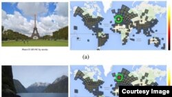
Internet search giant Google has unveiled an artificial intelligence that can identify where a photo was taken even without well-known landmarks, geotags or GPS.
The software, called PlaNet, uses a database of over millions of geotagged photos organized along 26,000 grids to compare different aspects such as building styles, languages and plant life.
“PlaNet is able to localize 3.6% of the images at street-level accuracy and 10.1% at city-level accuracy. 28.4% of the photos are correctly localized at country level and 48.0% at continent level," wrote the research team in a paper about the project, according to the Christian Science Monitor.
The team also compared how PlaNet compared with well-traveled humans.
Using the online game Geoguessr, PlaNet went up against 10 globetrotting humans.
"PlaNet won 28 of the 50 rounds with a median localization error of 1131.7 km, while the median human localization error was 2320.75 km," according to the paper.
There are some limitations to the software. For example, it wasn’t able to identify remote or infrequently visited areas.
While you might picture PlaNet as needing a room full of servers and supercomputers to run, the researchers say the program does not even take up half of a gigabyte, meaning it would easily fit on most smartphones.
Google Artificial Intelligence Knows Where Your Photos Were Taken
- By VOA News


