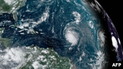
The U.S. National Hurricane Center says Hurricane Lee has reached dangerous category 5 strength in the Atlantic, with maximum sustained winds near 270 kilometers per hour and is likely to continue strengthening in the next 24 hours.
In its latest public advisory, the hurricane center said the storm was far out in the Atlantic – 1,015 kms east of the northern Leeward Caribbean Islands – which include the Virgin Islands, Puerto Rico, the Bahamas, and others.
Forecasters say Lee’s track is expected to be well to the north of those islands in the next several days, but the storm is expected to maintain its intensity. They warn it will likely create dangerous beach conditions and life-threatening currents for the islands and beaches along the U.S. East Coast early next week.
The hurricane center said it is too early to know what level of impacts – if any - the storm could have on the eastern United States or Bermuda by late next week. The storm is expected to slow down considerably as it moves to the north and west.
But the forecasters say dangerous surf and rip currents generated by the storm are expected along most of the U.S. East Coast beginning Sunday.
Meteorologists observing the storm say its development was dramatic. On his account on the social media platform X, Joint Typhoon Warning Center Senior Scientist Levi Cowan called Lee’s strengthening Thursday to Category 5 “one of the most impressive rapid intensification episodes” he has seen in the Atlantic.
The hurricane center is also watching Tropical Storm Margot further east in the Atlantic, which is expected to strengthen as it moves to the west and north over the next several days.


