The center of Hurricane Debby is expected to reach the Big Bend coast of Florida early Monday bringing potential record-setting rains, catastrophic flooding and life-threatening storm surge as it moves slowly across the northern part of the state before stalling over the coastal regions of Georgia and South Carolina.
Debby was located about 40 miles (70 kilometers) west of Cedar Key, Florida, with maximum sustained winds of 80 mph (130 kph). The storm was moving north at 12 mph (19 kph), the National Hurricane Center in Miami said early Monday.
Debby is the fourth named storm of the 2024 Atlantic hurricane season after Tropical Storm Alberto, Hurricane Beryl and Tropical Storm Chris, all of which formed in June.
Forecasters warned heavy amounts of rain from Debby could spawn catastrophic flooding in Florida, South Carolina and Georgia.
The storm was expected to make landfall around midday Monday in the Big Bend area of Florida, north of Tampa, the hurricane center said. A tornado watch also was in effect for parts of Florida and Georgia until 6 a.m. Monday.
"Right now, we are trying secure everything from floating away," said Sheryl Horne, whose family owns the Shell Island Fish Camp along the Wakulla River in St. Marks, Florida, where some customers moved their boats inland. The sparsely populated Big Bend region in the Florida Panhandle was hit last year by Hurricane Idalia, which made landfall as a Category 3 hurricane.
"I am used to storms and I'm used to cleaning up after storms," Horne said.
Debby was expected to move eastward over northern Florida and then stall over the coastal regions of Georgia and South Carolina, thrashing the region with potential record-setting rains totaling up to 76 centimeter) beginning Tuesday. Officials also warned of life-threatening storm surge along Florida's Gulf Coast, with 1.8 to 3 meters of inundation expected Monday between the Ochlockonee and Suwannee rivers.
"There's some really amazing rainfall totals being forecast and amazing in a bad way," Michael Brennan, director of the hurricane center, said at a briefing. "That would be record-breaking rainfall associated with a tropical cyclone for both the states of Georgia and South Carolina if we got up to the 30-inch level."
Flooding impacts could last through Friday and are expected to be especially severe in low-lying areas near the coast, including Savannah, Georgia; Hilton Head, South Carolina; and Charleston, South Carolina. North Carolina officials were monitoring the storm's progress.
Officials in Savannah said the area could see a month's worth of rain in four days if the system stalls over the region.
"This is going to a significant storm. The word historic cannot be underscored here," Savannah Mayor Van. R. Johnson said during a press conference.
The hurricane center said at 11 p.m. that Debby was located about 161 kilometers west of Tampa, Florida, with maximum sustained winds of 120 kph. The storm was moving north at 19 kph.
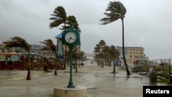
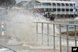
Debby's outer bands grazed the west coast of Florida, flooding streets and bringing power outages. Sarasota County officials said most roadways on Siesta Key, a barrier island off the coast of Sarasota, were under water. The hurricane center had predicted the system would strengthen as it curved off the southwest Florida coast, where the water has been extremely warm.
At a briefing Sunday afternoon, Florida Gov. Ron DeSantis warned the storm could lead to "really, really significant flooding that will happen in North Central Florida."
The storm would follow a similar track to Hurricane Idalia but would "be much wetter. We are going to see much more inundation," he said.
A hurricane warning was issued for parts of the Big Bend and Florida Panhandle areas, while tropical storm warnings were posted for Florida's West Coast, the southern Florida Keys and Dry Tortugas. A tropical storm watch extended farther west into the Panhandle.
Tropical storms and hurricanes can trigger river flooding and overwhelm drainage systems and canals. Forecasters warned of 15 centimeters to 30 centimeters of rain and up to 46 centimeters in isolated areas of Florida.
Storm surge expected to hit Gulf Coast, including Tampa Bay
Flat Florida is prone to flooding even on sunny days and the storm was predicted to bring a surge of 0.6 to 1.2 meters along most of the Gulf Coast, including Tampa Bay, with a storm tide of up to 2.1 meters north of there in the Big Bend region.
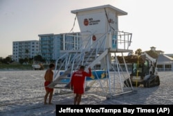
Forecasters warned of "a danger of life-threatening storm surge inundation" in a region that includes Hernando Beach, Crystal River, Steinhatchee and Cedar Key. Officials in Citrus and Levy counties ordered a mandatory evacuation of coastal areas, while those in Hernando, Manatee, Pasco and Taylor counties called for voluntary evacuations. Shelters opened in those and some other counties.
Citrus County Sheriff Mike Prendergast estimated 21,000 people live in his county's evacuation zone.
Residents, businesses prepare for flooding
Residents in Steinhatchee, Florida, which flooded during Hurricane Idalia, spent Sunday moving items to higher ground.
"I've been here 29 years. This isn't the first time I've done it. Do you get used to it? No," Mark Reblin said as he moved items out of the liquor store he owns.
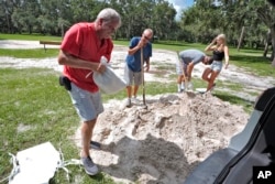
Employees of Savannah Canoe and Kayak in Georgia said they were busy tying down their watercraft, laying sandbags, and raising equipment off the ground. Mayme Bouy, the store manager, said she wasn't too concerned about the forecast calling for a potential historic rain event.
"But we do have some high tides this week so if the rain is happening around then, that could be bad," Bouy added. "I'd rather play it safe than sorry."
Governors declare emergencies ahead of landfall
DeSantis declared a state of emergency for 61 of Florida's 67 counties, with the National Guard activating 3,000 guard members. Utility crews from in and out of state were ready to restore power after the storm, he said in a post on X. Georgia Gov. Brian Kemp and South Carolina Gov. Henry McMaster made their own emergency declarations.
In Tampa alone, officials gave out more than 30,000 sandbags to barricade against flooding.
"We've got our stormwater drains cleared out. We've got our generators all checked and full. We're doing everything that we need to be prepared to face a tropical storm," Tampa Mayor Jane Castor said.
Northeast coast also preparing for storm conditions
Emergency managers in New England and New York were already monitoring the path of the storm for the possibility of remnants striking their states. States including New York and Vermont have been hit by heavy rain and thunderstorms in recent weeks and were still coping with flooding and saturated ground.


