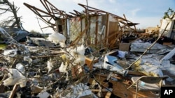
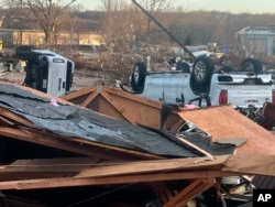
Forecasters are warning of more severe weather, including tornadoes, Tuesday and Wednesday in parts of the South and Midwest hammered just days ago by deadly storms.
That could mean more misery for people sifting through the wreckage of their homes in Arkansas, Iowa and Illinois. Dangerous conditions Tuesday also could stretch into parts of Missouri, southwestern Oklahoma and northeastern Texas. Farther south and west, fire danger will remain high.
"That could initially start as isolated supercells with all hazards possible — tornadoes, wind and hail — and then over time typically they form into a line (of thunderstorms) and continue moving eastward," said Ryan Bunker, a meteorologist with the National Weather Center in Norman, Oklahoma.
In Keokuk County, Iowa, where 19 homes were destroyed and more were damaged Friday, emergency management official Marissa Reisen worries how those cleaning up the damage will cope if another storm hits.
"All of the people who have been impacted by the storms Friday night are doing all this work, to clean up, to gather their stuff, to pile up the debris," Reisen said. "If a storm comes through and hits them again and throws all that hard work all over the place again, it will be so deflating to those people."
Severe storms could produce strong tornadoes and large hail Wednesday across eastern Illinois and lower Michigan and in the Ohio Valley, including Indiana and Ohio, according to the Storm Prediction Center. The severe weather threat extends southwestward across parts of Kentucky, Missouri, Tennessee and Arkansas.
Just last week, fierce storms that spawned tornadoes in 11 states killed at least 32 people as the system, which began Friday, plodded through Arkansas and onto the South, Midwest and Northeast.
The same conditions that fueled last week's storms — an area of low pressure combined with strong southerly winds — will make conditions ideal for another round of severe weather Tuesday into early Wednesday, Bunker said.
Those conditions, which typically include dry air from the West going up over the Rockies and crashing into warm, moist air from the Gulf of Mexico, are what make the U.S. so prone to tornadoes and other severe storms.
A blizzard warning was in effect for nearly all of North Dakota and most of South Dakota through at least Wednesday night. The National Weather Service predicted parts of South Dakota could see up to 16 inches of snow and wind gusts as high as 55 mph.
In Minnesota, a winter storm warning was in effect in the north, while the southern part of the state expected thunderstorms that could include hail and strong winds.
The state's popular EagleCam captured the moment in which high winds blew a 20-year-old eagle's nest out of a tree, killing an eaglet that had hatched just days earlier. Officials believed heavy snow that fell in a weekend blizzard — coupled with the weight of the more than 2,000-pound nest — became too much for the tree to support.
The threat of fire danger is expected to remain high Tuesday across portions of far western Oklahoma, the Texas Panhandle, northeastern New Mexico and far southeastern Colorado, with low humidity, dry vegetation and wind gusts as high as 110 kph, according to the National Weather Service.


