Researchers studying global climate change have taken to the skies in a flying laboratory that is at the forefront of scientific discovery.
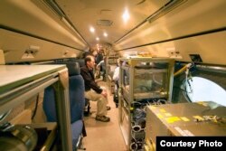
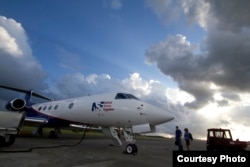
The lab is a Gulfstream V corporate jet that has been modified. In place of the luxury seats for business executives are banks of computers and dozens of weather instruments.
"Many of them [instruments] [are] mounted in locations around the fuselage," said Al Cooper, chief scientist with the National Center for Atmospheric Research (NCAR), who helped develop the flying laboratory.
Some of the atmospheric chemistry measurements inside the airplane allow scientists to gather data as they fly through the air. Others measure remotely through the airplane windows.
The flying lab is called HIAPER, which stands for High-performance Instrumented Airborne Platform for Environmental Research. HIAPER climbs high, to 16,000 meters, and travels far, more than 11,000 kilometers without refueling. Scientists helped craft the design and then lobbied to get it funded.
“The community was really asking for these kind of capabilities for several reasons: one was the altitude capabilities they wanted to reach the upper parts of the atmosphere," Cooper said. "The other was long-range capabilities, to be able to conduct studies that are global in scope, so that we can monitor questions like what is the carbon dioxide distribution around the world.”
The $81.5 million project was funded by the National Science Foundation. It is managed and operated by NCAR in Boulder, Colorado.
HAIPER collects data by flying over clouds and storms to the edges of the stratosphere, beyond the reach of most research aircraft. It can travel to remote regions over oceans and track atmospheric chemicals as they move around the globe. The instruments take measurements as events unfold.
“The main thing this gives us is the ability to measure in place," Cooper said. "There are some remote sensors that the plane carries as well to be able to extend those measurements above and below the plane as it flies along. So the instruments that it carries measure along the flight track and they measure with high resolution, much higher than you can get in any other way.”
Among the instruments taking measurements in real time are dropsondes packed in epoxy-hardened cotton tubes and jettisoned from the aircraft. NCAR engineer Nick Potts says they record pressure, temperature, humidity and wind speed. “As the sondes falls, it is measuring these parameters," he said. "It is telemetering them or radioing them out much like your cell phone talks to a base station, where instead of just talking to the base station, we are talking to the plane.”
From a seat behind a computer, Potts sends a message to an automated dropsondes launcher, which looks a lot like a vending machine in the rear of the craft. The tubes are stacked in slots waiting for his command.
“The aircraft, we can actually fly to where we are interested in going," Potts said. "So often times these things are used in hurricanes. So we fly to the hurricane, fly around the hurricane and then pick spaces where we want to launch them. What their real observational purpose is for is to help with prediction models for hurricanes and where they land.”
Potts says better predictions can ultimately save lives. Among HAIPER’s recent projects was a mission to study plumes of dust and pollutants blown from Asia, and flights to analyze severe weather across Colorado’s Front Range and the adjacent Great Plains.


