At least nine people have died in the most recent round of harsh weather to pummel the U.S., including eight people in Kentucky who died as creeks swelled from heavy rain and water covered roads.
Kentucky Gov. Andy Beshear said Sunday that hundreds of people stranded by flooding had to be rescued.
Beshear said many of the deaths, including a mother and 7-year-old child, were caused by cars getting stuck in high water.
“So folks, stay off the roads right now and stay alive,” he said. “This is the search and rescue phase, and I am very proud of all the Kentuckians that are out there responding, putting their lives on the line.”
Beshear said the storms have knocked out power to about 39,000 homes, but he warned that harsh winds in some areas could increase outages.
Much of the U.S. beyond Kentucky faced another round of biting winter weather. The Northern Plains faced life-threatening cold, and tornado watches were issued for parts of Georgia and Florida.
Hart County Coroner Tony Roberts said earlier that the mother and child were swept away Saturday night in the Bonnieville community. In southeastern Kentucky, a 73-year-old man was found dead in floodwaters in Clay County, County Emergency Management Deputy Director Revelle Berry said.
Parts of Kentucky and Tennessee received up to 6 inches 15 centimeters (6 inches) of rain during the weekend storms, said Bob Oravec, a senior forecaster with the National Weather Service.
“The effects will continue for a while, a lot of swollen streams and a lot of flooding going on,” Oravec said Sunday. “Any time there’s flooding, the flooding can last a lot longer than the rain lasts.”
In Atlanta, a person was killed when an “extremely large tree” fell on a home early Sunday, according to Atlanta Fire Rescue Capt. Scott Powell. He told reporters that firefighters were dispatched just before 5 a.m. after a 911 call.
Elsewhere, bone-chilling cold is expected for the Northern Plains with low temperatures into the minus 30s Celsius (minus 30s Fahrenheit) near the Canadian border. Dangerously cold wind chill temperatures in the Dakotas and Minnesota of minus 40 Celsius (minus 40 Fahrenheit) to minus 45.6 Celsius (minus 50 Fahrenheit) are expected.
Heavy snowfall amounts were expected in parts of New England and northern New York. In some areas, wind gusts could reach about 97 kph (60 mph) and create “hazardous whiteout conditions,” the NWS said.
Kentucky faces severe flooding
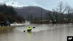
Water submerged cars and buildings in Kentucky and mudslides blocked roads in Virginia late Saturday into Sunday. Both of the states were under flood warnings, along with Tennessee and Arkansas. The National Weather Service warned residents to stay off the roads.
Chilly temperatures replaced the heavy rains with snow early Sunday in parts of Kentucky.
The Kentucky River Medical Center in the city of Jackson said closed its emergency department and was transferring all patients to two other hospitals in the region. The hospital said it would re-evaluate conditions Sunday morning to determine when it can safely reopen. The north fork of the Kentucky River was forecast to crest nearly 4.3 meters (14 feet) above flood stage that afternoon, the weather service said.
Photos posted by authorities and residents on social media showed cars and buildings underwater in south-central and eastern Kentucky. In Buchanan County, Virginia, the sheriff’s office said multiple roads were blocked by mudslides.
The Simpson County Office of Emergency Management in Kentucky said authorities performed several rescues from stalled-out vehicles in floodwaters.
“Stay home if you can,” the office said on Facebook.
New England faces snow, then sleet
Meanwhile heavy snow was expected to blanket much of New England and then transition to sleet.
Oravec said Sunday that snowfall in the region was relatively light, due to the freezing rain and sleet mix.
Snow and arctic temperatures swept much of the Midwest and Upper Plains on Saturday, covering roads in eastern Nebraska, northern Iowa and much of Wisconsin. Winter weather advisories were issued for parts of those states and Michigan, with up to 10.6 centimeters (4 inches) of snow predicted throughout Iowa, southern Wisconsin and most of Michigan by Sunday evening.
Frigid polar vortex
Meteorologists said the U.S. was about to get its 10th and coldest polar vortex stretching event this season, with the northern Rockies and northern Plains first in line. Weather forces in the Arctic are combining to push the chilly air that usually stays near the North Pole into the U.S. and Europe.
In Denver, where temperatures were expected to dip as low as minus 10 degrees Celsius (14 degrees Fahrenheit) over the weekend, the city opened shelters for those living on the streets.