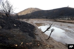
Flash flooding hit a wildfire-scarred area of Northern California on Thursday, forcing officials to quickly deploy swift water rescue teams to save people stranded in vehicles after a downpour near the Paradise area, officials said.
It was not clear how many people were trapped, but authorities received reports of flooding on roads and of downed trees and utility poles.
“The roots and the bottoms of the utility poles are just kind of swimming,” said Rick Carhart, a spokesman with the California Department of Forestry and Fire Protection. “It rained really hard in a short amount of time and this whole thing came up really quickly.”
The storm brought heavy rains, toppling trees and trapping motorists in flooded roads downstream, said National Weather Service meteorologist Craig Shoemaker.
“This is heavy rain in a short period of time and that’s the worst thing that can happen in the burn scar,” he said.
The Butte County Sheriff’s Department ordered evacuations but could not say how many people were affected. The water rescues were in an area of Chico, which is downhill from Paradise, and a city where many of the wildfire evacuees have been staying since the town of 27,000 was destroyed just three weeks ago by a deadly wildfire.
Butte County Sheriff’s Sgt. Brad Meyer told television stations KHSL/KNVN in Chico that about a dozen homes were affected and rafts were being used to rescue people from water that was a couple of feet deep.
“It is serious. The water is coming up so we want to make sure we get everybody out that we can,” Meyer told the station.
Emergency response crews earlier cleared a tree that toppled in the town of Magalia, but no other reports of damage had been received after an inch of rain fell overnight in the burn zone about 140 miles (225 kilometers) northeast of San Francisco.
Paradise has been under mandatory evacuation orders for nearly three weeks since a wildfire killed at least 88 people and destroyed nearly 14,000 homes.
Residents could begin returning early next week, but only if the storm doesn’t hinder efforts to clear roads and restore power, said Sheriff Kory Honea.
No major problems were reported in burn zones in Southern California early Thursday, but numerous traffic accidents occurred on slick Los Angeles-area freeways and most vehicles traveling in the mountains were ordered to put chains on their tires.
On the coast near Big Sur, the California Department of Transportation closed a 12-mile (19-kilometer) stretch of Highway 1 because of potential instability.
The scenic route perched between towering mountainsides and the ocean has been dogged by slides since 2016. But the one that hit in May 2017 was monumental, requiring extensive work to rebuild the highway.
In Southern California, residents were urged to voluntarily evacuate a string of neighborhoods about 45 miles (70 kilometers) southeast of Los Angeles along a flank of the Santa Ana Mountains where a fire burned thousands of acres last summer. Mandatory evacuations were ordered for a small section of the city of Lake Elsinore beneath a burn zone.
West of Los Angeles, rain fell heavily at times in vast areas burned by fires this month and last December — an area where there are strong memories of a January downpour that unleashed devastating debris flows through the community of Montecito that killed 21 people and left two missing.
In the zone that burned this month, the city of Malibu warned of rocks falling on canyon roads and Pepperdine University closed its campus.
The weather service also issued a backcountry avalanche warning for most of the central Sierra, including the Lake Tahoe area.


