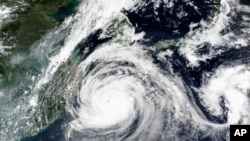
The strongest typhoon of the year is on its way to the Korean Peninsula Wednesday after lashing Japan with strong winds and rain.
Typhoon Maysak peaked early Tuesday with winds of 233 kilometers per hour, coming within a week of the first major storm and a few days before a third potential typhoon.
Maysak, a Category 4 storm on the five-level scale, could affect weather as far away as Canada.
Maysak is expected to make landfall Wednesday in South Korea as a Category 1 or Category 2 storm. Prefectures along Japan’s eastern coast were still under weather advisories Tuesday, with some at the southern tip of the island under more serious weather warnings.
Busan, South Korea’s second-largest city, is predicted to lie in the path of the strongest quadrant of the storm, raising fears of storm surges and flooding, according to the Washington Post. More than 3.4 million people live in Busan.
“It is expected that the whole country will be affected by typhoons from the far south of Jeju Island to the day after tomorrow,” tweeted the Korea Meteorological Administration Tuesday.
"Very strong winds and very much rain across the country, very high currents, and some coastal storm surges!"
This year’s Pacific typhoon season, typically busiest between May and October, has been unusually uneventful thus far.
But last week, Typhoon Bavi, weaker than Maysak, dumped significant amounts of rain on the Korean Peninsula, which this year has already experienced one of its longest and wettest monsoon seasons on record.
Bavi and Maysak aren’t the end of it. Kyushu, Japan’s southernmost main island, and both Koreas are bracing for another developing storm system, Tropical Storm Haishen, to hit later this week.
Korean weather authorities predicted Tuesday that Haishen could strengthen to a Category 4 storm with maximum sustained winds of 162 kilometers per hour by Saturday.
The Japan Meteorological Administration noted Tuesday that sea surface temperatures around the country in August were the highest on average since record-keeping began in 1982, contributing to the unusual number of serious storms in the Western Pacific.
Videos on social media showed Maysak whipping sheets of rain and gusts of wind Monday night across Okinawa.


