Low-cost eyes in the sky are helping the storm-prone Philippines plan for a wetter, more extreme future.
Agriculture officials are deploying drones to help farmers adapt to climate change.
The archipelago is among the most disaster-prone places on the planet, with some 20 super storms a year.
Last year, Typhoon Koppu forced tens of thousands of people from their homes. In 2013, Typhoon Haiyan tore through the islands, leaving 6,300 people dead and 4 million more desperate for food and shelter. In addition, 600,000 hectares of farmland was lost, causing more than $700 million in damage to the nation's agriculture industry.
Scientists are just beginning to establish a link between big weather events like drought and flooding, and climate change, but there's no question that extreme weather gets worse as the Earth's temperature climbs.
Climate risks mapped
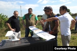
In a pilot program between the U.N. Food and Agriculture Organization and the Philippine government, technical experts are making test flights over farmers' fields to collect data that identifies climate risks. Equipped with sensors to map and photograph farmers' fields, the small craft can cover up to 600 hectares a day.
Those drones provide images of what is happening on the ground, according to Christopher Morales, director of field operations in the Philippine Department of Agriculture.
"Before, we were just concentrating on reports of our local counterparts, which might be either overestimated or underestimated," he said. The drones are a scientific tool, he added, so by "analyzing the data, we can suggest appropriate interventions in times of disaster."
Data directs response
Information from drones could help farmers know where to build retaining walls or irrigation or storage facilities, or pinpoint where to plant protective vegetation or how to adapt farming practices.
In addition, drones could be deployed to access immediate risks days before a predicted storm reaches landfall, "so that we can approximate or do an estimation of pre-disaster assessment so we can plan ahead and respond accordingly," according to Morales.
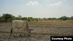
He also sees a role for drones in response to drought conditions like the extreme dry spell currently hitting the Philippines as a result of an intense El Nino weather pattern.
"We are developing a cloud seeding prototype," he said.
Morales hopes to put agricultural drone teams to work across the country, based on the level of private and public investment. The relatively cheap technology, he says, can mean the difference between having to start over after the next big disaster, and weathering the storm.


