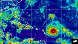
People in the Leeward Islands are preparing for the arrival of powerful Hurricane Irma late Tuesday or early Wednesday, as areas to the northwest, from Puerto Rico to Cuba to the coastal United States, wait to see the track the storm will take as the week progresses.
The U.S. National Hurricane Center said Irma was a Category 5 storm, the most severe designation, meaning its sustained winds of more than 230 kilometers per hour (143 mph) will severely damage homes, uproot trees and power poles and knock out power in affected areas for weeks.
“We're looking at Irma as a very significant event,” Ronald Jackson, executive director of the Caribbean Disaster Emergency Management Agency, said by phone. “I can't recall a tropical cone developing that rapidly into a major hurricane prior to arriving in the central Caribbean.”
In addition to the wind damage, forecasters expect the storm to drop 7 to 15 centimeters (3-6 inches) of rain across the northern Leeward Islands, the British and U.S. Virgin Islands and Puerto Rico. The rain could cause dangerous flash floods and mudslides.
Officials in Puerto Rico have declared a state of emergency and activated the National Guard in anticipation of Irma's expected arrival there by late Wednesday.
In the U.S. state of Florida, Governor Rick Scott also declared an emergency across the entire state in order to give local authorities time to prepare for a potential landfall.
U.S. disaster management teams are dealing with the after effects of Hurricane Harvey, which was a Category 4 storm when it made landfall late last month in the state of Texas and dropped historic amounts of rain as it stalled over the region.


