The first of two storms predicted this week brought some snow to the mountains and mostly modest amounts of rain as it moved through California on Monday, but some authorities were cautious about the potential for mudslides and debris flows.
The storm descended through the San Francisco Bay Area in the morning and dropped snow in the Sierra Nevada, where travel was hobbled on Interstate 80 and U.S. 50.
The relatively narrow storm band continued southward along the coast and also brought rain to the state's Central Valley agricultural heartland.
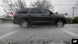
In Sacramento, a brief hail storm blanketed the Capitol grounds in white, with lawmakers heading outside to take selfies. Fire officials shared photos of cars stuck in a coating of slush, warning drivers to be careful.
On the south coast of Santa Barbara County, where the community of Montecito is still trying to recover from devastating debris flows that hit during a storm last month, officials issued a "pre-evacuation advisory" ahead of the storm's anticipated arrival late Monday or overnight.
The advisory is the first stage in a new three-level alerting system created to eliminate the word ``voluntary.''
In the aftermath of the disaster, officials concluded that some residents focused more on the idea that they had discretion than on the suggestion or order to evacuate.
The advisory means there is a possible risk to life or property and people should prepare to leave, monitor the situation and leave any time they feel threatened even if there isn't yet an additional notification.
The next two levels are a "recommended evacuation warning" and a "mandatory evacuation order."' The latter does not allow officials to forcibly remove people from their homes, but residents shouldn't expect rescue or other assistance when an event begins.
Santa Barbara County issued the pre-evacuation advisory based on instability in the weather system that could trigger thunderstorms.
By early afternoon, however, the National Weather Service said it expected the system to weaken significantly by the time it reached that area.
Forecasting models indicated the unstable air would be pushed farther off the coast and away from land, "further reducing the already very small chances for any heavier rain rates near the burn areas," the weather service said.
The chance of rain rates reaching levels that could cause significant mud and debris flows was put at less than 5 percent.
Snow levels were expected to fall to fairly low levels after midnight in Southern California, bringing potential difficulty for motorists traveling Interstate 5 over Tejon Pass and Interstate 15 over Cajon Pass.
Forecasters said the next weather system will arrive in Northern California on Wednesday and reach the south by Thursday, bringing much more precipitation.


