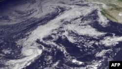
Parts of the nation's northernmost state are bracing for heavy rains and strong winds from the remnants of Hurricane Oho.
Tropical storm conditions are expected to combine with a low-pressure system to bring potentially 2 to 6 inches of rain to southeast Alaska through Friday, according to weather officials.
The expected tropical system will be the latest unusual weather event to hit Alaska in 2015: sparse snowfall pushed the start of the Iditarod sled-dog race 400 miles to the north; dry conditions fueled one of Alaska's worst fire seasons; but soggy weather in Juneau made for an especially wet summer.
Last year, Juneau, which is in a rainforest, had its wettest summer on record, with more than 24 inches of rain. This summer came in a close second.
Rick Thoman, a regional climate scientist with the National Weather Service in Alaska, said Alaska's run of sustained odd weather started in the spring of 2013, which saw exceptionally cold weather across mainland Alaska. By the end of May that year, though, "the switch got flipped," he said, with much of the state experiencing warmer conditions since then.
Oho was among a record number of tropical cyclones in the central Pacific so far this hurricane season, which officials attributed to unusually warm ocean temperatures from El Nino.
While it's not unusual for Alaska to feel the remnant effects of tropical storms from the west, it's rare for the remnants of a central Pacific tropical storm to reach this far because tropical systems north of Hawaii often fall apart rapidly as they reach cooler water temperatures, said meteorologist Shaun Baines of the weather service's Anchorage office.
El Nino often means mild weather, particularly in the second half of winter, for much of Alaska, Thoman said.
While the state has seen wild weather of late, it's hard to tie any single season or year to long-term changes, Thoman said. But signals of climate change can start to emerge from data spanning a decade or more.
Eight of the 10 wettest summers in Juneau have occurred since 2000, he said. Records for the site date to the early 1940s. The frequency of wildfire seasons where at least a million acres have been burned has roughly doubled since the early 1990s, he said.
With trends at that scale, it's harder to say it's "just the weather," he said. "It could be, but 10, 20, 30 years of signaling to see these persistent changes, that's what we're looking for when we're looking for climate-change signals."


