The U.S. National Weather Service is predicting that two storm systems in and around the Caribbean Sea will strengthen and could both be hurricanes next week in the Gulf of Mexico.
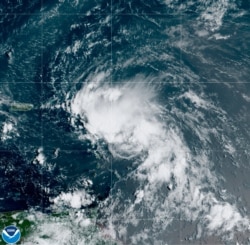
The National Hurricane Center reported Tropical Storm Laura formed early Friday just northeast of the Lesser Antilles, and on Friday evening was 65 kilometers east of Antigua.
The Washington Post reports Laura is the earliest forming “L” named storm on record, beating out Tropical Storm Luis, which formed on August 29, 1995. The season has already featured the earliest-forming C, E, F, G, H, I, J and K storms on record.
Meanwhile, further to the west, in the southern Caribbean, forecasters are watching Tropical Depression 14, which they say will likely strengthen into Tropical Storm Marco.
Forecasters say both storms will likely move into the Gulf of Mexico and could become hurricanes by early next week. If they do, it will be the first time two hurricanes are in the gulf at the same time in the satellite era.
Some computer models say both hurricanes could hit the southern United States at roughly the same time, or could interact with each other in some way, depending on their size.
Tropical storm warnings have been issued across the Caribbean, including in Puerto Rico, the U.S. Virgin Islands, Haiti, the northern Leeward Islands and the southeast Bahamas. Monroe County in the Florida Keys declared a state of emergency Friday and ordered mandatory evacuations for people living in boats and mobile homes.
Tropical Depression 14 is expected reach the eastern Yucatan coast of Mexico by midday Saturday, where tropical storm warnings are in effect. It is forecast to move into the south-central Gulf of Mexico by Sunday afternoon.


