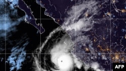
Hurricane Orlene grew to Category 4 strength Sunday as it headed toward Mexico's northwest Pacific coast between the tourist towns of Mazatlan and San Blas.
After growing into a hurricane Saturday, Orlene quickly added power, and its maximum sustained winds were up to 130 mph (215 kph) by early Sunday, according to the U.S. National Hurricane Center.
The storm was forecast to roar past the Islas Marias, a former prison colony being developed as a tourist draw, late Sunday and then head for a sparsely populated, lagoon-dotted stretch of the mainland by Monday night or early Tuesday.
Orlene was centered about 105 miles (170 kilometers) southwest of Cabo Corrientes — a point of land that juts into the Pacific just south of Puerto Vallarta — and was headed north at 7 mph (11 kph) early Sunday.
A hurricane warning was in effect from San Blas to Mazatlan.
The center said the storm would likely strengthen more Sunday, then begin weakening as it moved closer to land. But it was still projected to hit as a hurricane.
It could bring flood-inducing rainfall of up to 10 inches (25 centimeters) in some places, as well as coastal flooding and dangerous surf.
Puerto Vallarta closed its port to ship and boat traffic Saturday as a precaution.
Mexico's National Water Commission said Orlene could cause “mudslides, rising river and stream levels, and flooding in low-lying areas.”
The hurricane center described Orlene as a small storm, with hurricane-force winds extending out about 10 miles (20 kilometers) from the center and tropical storm-force winds out to 60 miles (95 kilometers).


